Hurricane Zeta Prep Update from City of Covington Mayor Mark Johnson. Sign up for email updates at www.covla.com
Covington’s own meteorologist Michael Efferson offers a very concise and most useful update on this week’s hurricane:

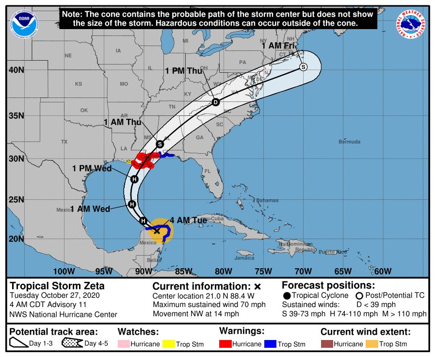
Hurricane Zeta: – The forecast track remains similar to pretty much every previous one. Climatology favors a more easterly one if any changes do occur.
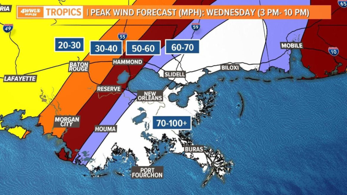
Timing: Wednesday afternoon-midnight for peak conditions for southeast LA. It’s short because Zeta will be moving fast.
Here’s what I’d be most concerned with in southeast LA:
1. Flash flooding: rain will be heavy, even today(Tuesday). We’ve seen heavy rainfall events the day before landfall many times before. I’m talking parish sized flood events. Be careful driving and watch out for flooded roads
2. Winds: For those east of I-55, we saw some trees down and relatively short-term power outages with Delta. I’d expect similar, if not slightly worse conditions with Zeta.
3. River Flooding: Probably the lowest threat but non-zero. We can handle roughly 5-7″ of rain without more than moderate river flooding. More than that would be problematic.
City Impacts from most to least:
New Orleans/Slidell: 50-75mph winds. Expect scattered trees down and power outages lasting from a few hours to a day or 2. Localized street flooding likely. Covington: 40-65mph winds. Expect isolated to scattered trees down, no power loss to a day or 2 at most. Think similar to slightly worse than Delta impacts. Hammond: 30-50 mph winds. Isolated trees down and maybe powerloss for less than a day.
Baton Rouge: 25-35 mph. No real-world wind impacts. BUT, localized street flooding possible today and tomorrow.

**UPDATE 10-28-2020** from Covington’s own meteorologist Michael Efferson:
Winds look as bad or worse than I mentioned yesterday across New Orleans and Slidell. Covington, Hammond and Baton Rouge should be about the same.
Bottom Line:
- Take this storm seriously. It WILL be worse than hurricane Delta was for those east of I-55 (Covington, Slidell, New Orleans metro)
- Get your errands finished by noon.
- 4 to 6 hour window of intense rain and dangerous winds
- It will not be safe to be on the roads late this afternoon.
- Winds should rapidly relax after around 9-10pm.
City Impacts from most to least:
New Orleans/Slidell: 60-90mph winds. Expect scattered trees down and power outages lasting from a few hours to a few days. Localized street flooding likely.
Covington: 40-70mph winds. Expect isolated to scattered trees down. Many will lose power for short period to a day or 2. Localized street flooding likely.
Hammond: 30-50 mph winds. Isolated trees down and maybe powerloss for less than a day.
Garbage / Recycling Pickup
Garbage will be picked up tomorrow morning (Wednesday) — But not per usual. Trucks will be running early to beat the storm.
Customers are advised to place bins out this evening, then secure bins tomorrow after pick up, prior to storm.
Assuming storm path and timing does not change, recycling will remain on Thursday.
After the storm: Leaves and clippings should be bagged and placed curbside on garbage day. Small piles of branches should be consolidated amongst neighbors (making the boom-trucks more efficient).
Changes in pick up schedule will be posted by Coastal Environmental Services on Facebook and on their website:
Coastal Environmental Services
Covington is a No Wake Zone

Covington Public Works is pre-positioning barricades for frequent flood hot-spots as well as cleaning culverts / catch basins. Big thanks to those residents who adopt a ditch or catch basin to check and clean prior to storms ( RivF : ).
Reminder: Covington streets are a NO WAKE ZONE. Though you may drive through safely, your wake rolls up into businesses and homes that otherwise would not flood. Avoid flooded streets when possible … go slow when unavoidable. Be kind.
Covington Fire Department will be checking on our most vulnerable, home-bound residents prior to the storm.
Covington Police Department will be on stand-by.
Sewer Lift Station – Generators are fully fueled.
CLECO order of re-energizing outages: 1) Hospitals 2) Nursing Homes 3) Sewer Lift Station / Treatment Plant 4) Traffic Signals 5 ) Residential Neighborhoods.
Repair crews are being pre-positioned today. To monitor outages & repair times, use CLECO’s app or Outage Map.
City Hall will be closed on Wednesday, October 27th
Visit www.covla.com for more information or to sign up for Mayor Mark’s email updates.
Read about St. Tammany Parish Government Emergency Operations for Hurricane Zeta, including self-serve sandbag locations:


